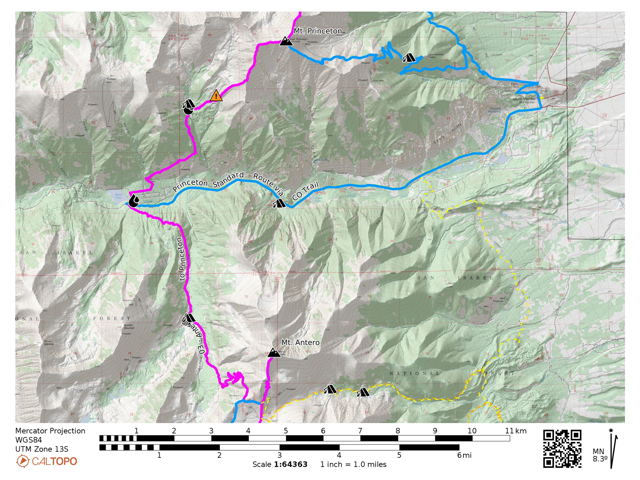
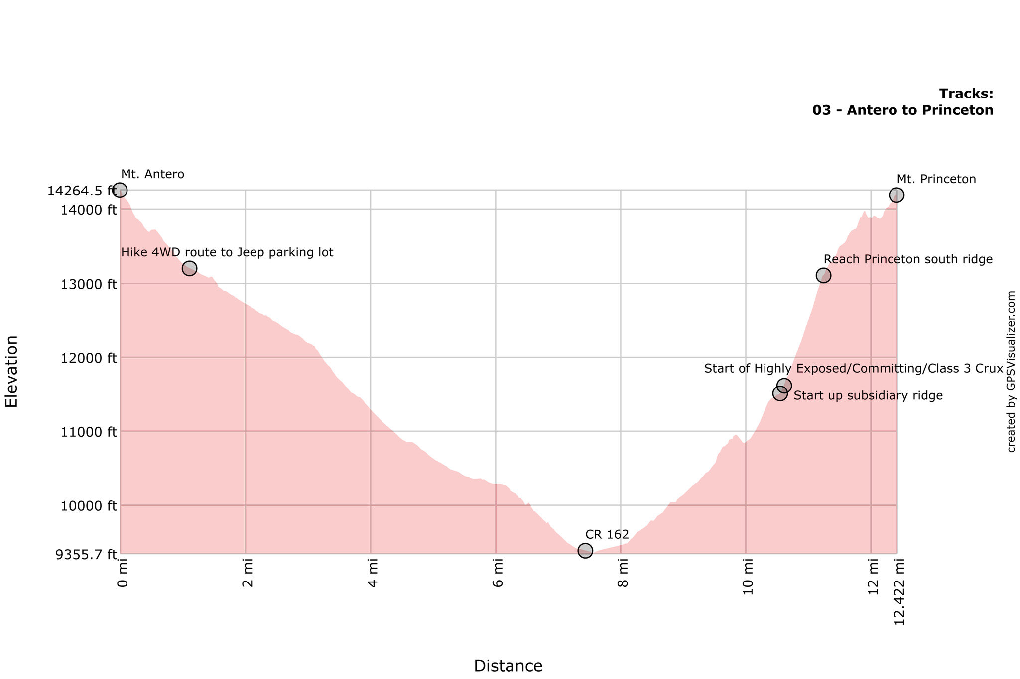
From Antero, the hike down to the valley floor is a long one on a somewhat busy 4WD track, but it’s worth the potential lonely camping at the top of Grouse Canyon! The hike along Mt. Princeton’s south ridge is one of the more incredible positions of the whole line, but if daylight is running short, save it for the next day.
Nolan’s 14 Line Stats
- 12.46 Miles
- +5070′
- -5128‘
Nolan’s 14 Line
0.0 From the summit of Antero, reverse your track south on the social trail, back to the Jeep parking lot.
0.56 Follow the Mt. Antero 4WD track (CR 278-A) to the Baldwin Gulch 4WD track. You may consider descending directly west from where the social trail to the summit of Antero starts, but currently this part of the mountain is gated off as it’s being actively mined for aquamarine. Crossing such a gate would be a great way to get a gun pointed at you by miners looking for claim jumpers.
1.44 A few disorganized 4WD tracks are found here on the west shoulder of Mt. Antero. Turn right heading north onto CR 278.
4.6 FSR 278/FSR277 trail junction. Continue descending north on CR 277 to CR 162.
7.3 CR 162. Turn right heading east on CR162 for a few hundred feet.
7.48 CR 162/CR 292 junction. Turn let heading north on CR 292 into the small hamlet of Alpine. Please respect the private property and privacy of those that live here. Cross CR292A.
7.72 CR 292/CR 292B junction. Right right heading east on CR 292B.
8.03 At the end of CR 292B is a very interesting historical cemetery and the start of a small trail that will lead you up onto the slopes below Mt. Princeton. Follow the unique trail markers. Once the trail gains elevation, you’ll find it to be one amazing piece of singletrack.
9.25 The trail will turn abruptly to the north at a deep gulch and follow and seasonal creek into a basin west of Mt. Princeton.
10.06 At a reasonable point, cross this creek, and then cross over a lateral moraine.
10.59 Start climbing onto a southwest ridge that will converge into the south ridge of Mt. Princeton itself.
11.27 Mt. Princeton South Ridge. Along this ridge is the “Class 3” crux of the whole line, so be prepared to take a little time to find the easiest and safest line you can. Most likely, you’ll find it just to the the east of the ridgeline proper, but it’s advised to not get off too far from the ridgeline – just a few feet or so. Once past this crux, more ridge scrambling follows, so take it slow and watch out for loose rock.
11.92 At a false peak, the ridgeline will turn east towards the actual summit of Mt. Princeton.
12.42 Mt. Princeton.
Slowlans Alternative
If the long ridgeline and Class 3 crux is not to your liking, your option is to head east on CR 162, past Alpine, and towards Mt. Princeton Hot Springs. Good chance you can hitch a ride, as this road is quite busy during the summer months. If you’ve indulged this far in hitching a ride, keep going with some ice cream at the small store and a dip in the springs.
Once at Mt. Princeton Hot Springs, follow the Colorado Trail north. The Colorado “Trail” at this point is a paved, then dirt road. Before it becomes singletrack again, turn left to continue on CR 322 towards the radio towers, then right onto a trail that comprises the standard East Slopes route of Mt. Princeton (14ers.com route description).
Although rated Class 2, rather than Class 3, you will still encounter loose rock, and this route isn’t particularly enjoyable.
Water
- Water may be available below the main set of switchbacks, on the 4WD track at Baldwin Gulch. (38.68213,-106.27301)
- Water is also available at the beginning of Baldwin Gulch, near the hamlet of Alpine. (38.71071,-106.28943)
- Water (best source) is available above Alpine, in a seasonable creek you cross, before heading up and over the lateral moraine to reach the ridgeline to Mt. Princeton. If the creek seems to be running dry, continue following it as recent log jams hide most of the flow. (38.73302,-106.27252) A branch of the creek follows the moraine up to where you need to go, and could be flowing better than the creek below (38.73356, -106.27028).
Camping
- Dispersed Campsites can be found along the 4WD track on Baldwin Gulch. You’ll be sharing them with 4WD enthusiasts and rock hounds (38.68250,-106.27243).
- Cascade Campground , a NFS campground is off-route from the main Nolans line, east of Alpine on CR 162. It will most likely be busy, first come/first served, and cost a few bucks (38.71008,-106.24453).
- Hot Springs and hotel rooms are available at Mt. Princeton Hot Springs! Live it up! (38.73189,-106.16715)
- Wonderful dispersed camping is located above Alpine, near the seasonal creek you cross, before heading up and over the lateral moraine to reach the ridgeline to Mt. Princeton. Chances are great you’ll find yourself with little company. Be prepared for back country primitive conditions. Hunters are probably the most prevalent visitors to this area, so if it is hunting season, considering wearing some blaze orange. (38.73407,-106.27252)
Bailing/Resupply
At the bottom of Baldwin Bulch is CR 162. Head east on CR 162, back to civilization. There are no services in Alpine, only private summer homes. Hitching a ride is most likely possible. The closest food is at Mt. Princeton Hot Springs, which has a small store that includes some overpriced camping food-like items, as well as a restaurant with very slow service. But, did we mention: hot springs?
Skipping
Head east on CR 162 Drive to Mt. Princeton Hot Springs with a good chance to hitch. Once at Mount Princeton Hot Springs, follow the Colorado Trail north, until Maxwell Creek and rejoin the main line (38.77221,-106.21385).
Next: Mt. Princeton to Mt. Yale