Get ready for a bushwhacking party into a jaw-dropping high alpine basin! Huron is a mysterious mountain when traveling in its eastern basin. It’s southern flanks are some of the most beautiful in the Sawatch. Get ready for talus hopping and boulder scrambling, the likes of which you’ve not seen since Columbia to Harvard. The last pitch up Huron’s steep east slopes is steep, loose, and dirty.
Nolan’s 14 Line Stats
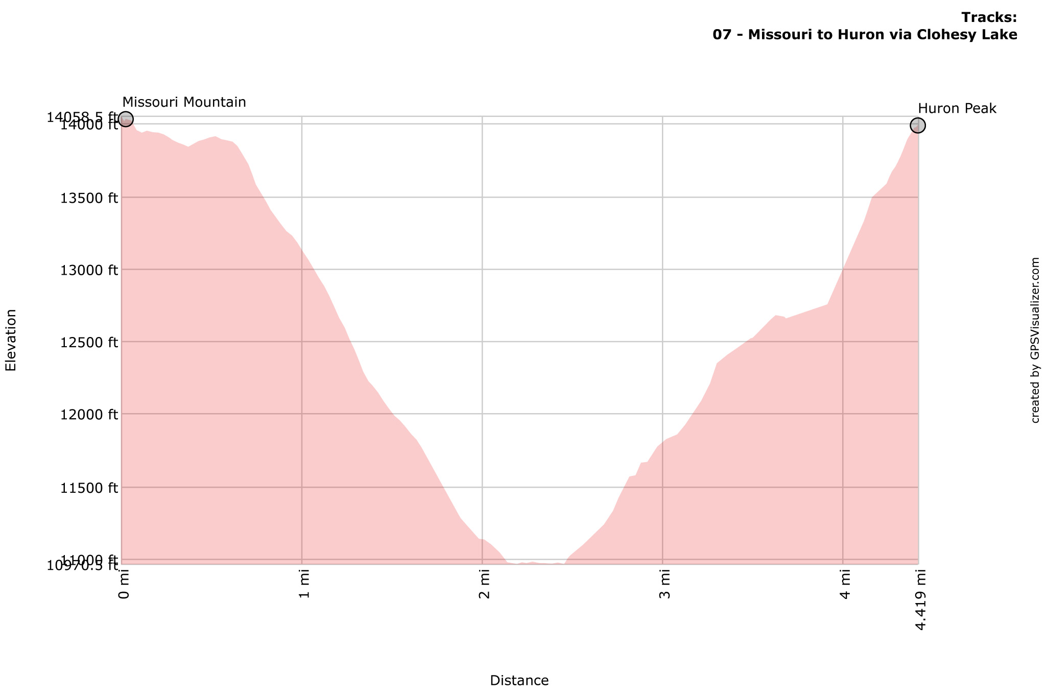
- 4.42 miles
- +3140′
- -3206′
Nolan’s 14 Line
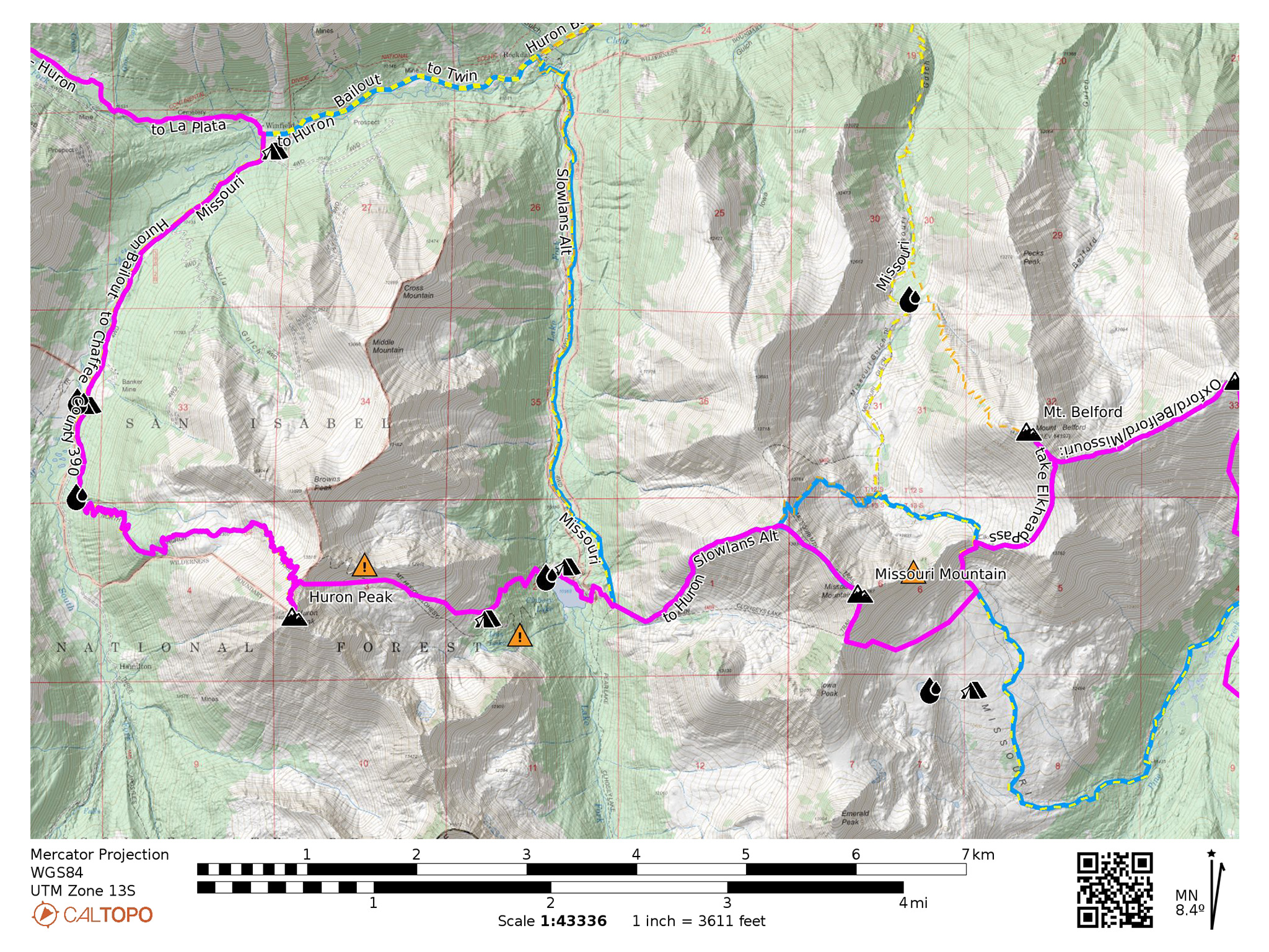
0.0 Summit of Missouri Mountain. Head northwest down the ridge of the standard route until 13,867′.
(Alternatively, you can scree ski from pretty much the summit of Missouri down west into the basin below. For the uninitiated, it’s exceptionally unpleasant. A better, more stable line is found by going south on a social trail from the summit, and starting your line a few hundred feet from the summit. Hit the bottom of the enormous scree field, hike out down towards Clohesy Lake and pick up the west ridge trail and continue on the narrative from there.)
0.63 Turn left off the standard route, heading west down a ridge. A trail will appear, becoming much more easier to follow the lower you go. The trail will veer into the basin to the south, following a creek. You’ll come across a few trail junctions, head towards Clohesy Lake.
2.14 Wrap tightly around the north side of the lake, and find a reasonable place to cross it just to the north on stepping stones.
2.46 Once across, continue generally west up the east slopes of Huron Peak.
Be aware that many maps maps show a deeply switchbacking trail just to the south of the of the lake but this trail has been reabsorbed into the forest and for all intents and purposes does not exist below treeline. What you will find here is a good amount of deadfall and a sprinkling of cliffs. Above treeline, only a cairned route exists, but it’s path is difficult and inefficient, taking you straight through a rock glacier.
Rather, just north of the lake, there is a social trail that shows some history of maintenance. From the north side of the lake and once across the stepping stones, find a rough trail that switchback west into the forest between the boundary of the pine trees and aspens.
If you have trouble picking the trail up at the bottom, just steeply hike west, until you find a dirt path that travels southwest up the slopes, into the forest. From there, a trail should be reasonably easy to follow, although many different braidings exist, as the best line to take has constantly changed due to deadfall.
The forest will thin out a little and open fields will pop up. An old miner’s cabin can also be found.
3.04 Make your way through the stunted trees and shrubs towards the talus field above. The view to the south is one of the best on the route and camping up high in this basin would be ethereal.
3.76 Above, many maps show another deeply switchbacking trail, going up the east ridge of Missouri, but this trail may never have existed in the way it’s portrayed on maps. The original trail more than likely ended at a small mine and went no further. Afterwards, you will find a highly technical ridgeline with nearly unclimbable gendarmes. You could gain the ridge near its apex, but do not approach the lower portions of the ridgeline hoping to find a quick and easy way through.
Instead, head directly up the talus which turn into steep gravel slopes to the Brown’s Peak/Huron ridge. This slope starts out reasonable, but will get very steep and loose. This may be one of the more dangerous parts of the entire line, so be careful, especially when traveling with a partner, as rocks may roll.
4.16 Join up with Huron’s standard route trail. Take this trail to Huron’s summit.
4.41 Summit of Huron Peak
Slowlans Alternative
The terrible scree climb up the east slopes of Huron is certainly not for everyone.
From the Clohesy Lake, take the 4WD track north to Chaffee County 390. Take a left and head west on Chaffee County 390 to the start of the standard route of Huron Peak. Take this route to the summit.
Water
- Water is plentiful at Clohesy Lake (38.94878,-106.41143)
- Seasonal creeks and flows can be found in Huron’s east-facing basin and at Lois Lake (38.94331,-106.41847)
Camping
- Camping can be found around Clohesy Lake, but solitude may not come with it (38.94729,-106.40707)
- Camping can be found in Huron’s east-facing basin. (38.94536,-106.41761)
Bailing/Resupply
Take the 4WD track north to Chaffee County 390. Turn right onto Chaffee County 390 heading east.
Skipping
Hike down to Clohesy Lake and take the 4WD track north to Chaffee County 390. Head west on Chaffee County 390 to Winfield. Pick up the Nolan’s 14 route from Huron to La Plata here. Tons of camping can be found in between.