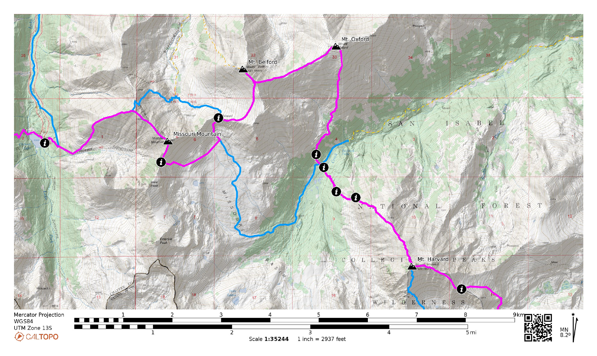

From the summit of Mt. Harvard, it’s hard not to be overwhelmed by the massive monsters you still have to summit while peering over to the north. The Sawatch 14ers found along Chaffee County 390 present a formidable challenge. Only one thing separates you from them: Pine Creek!
Nolan’s 14 Line Stats
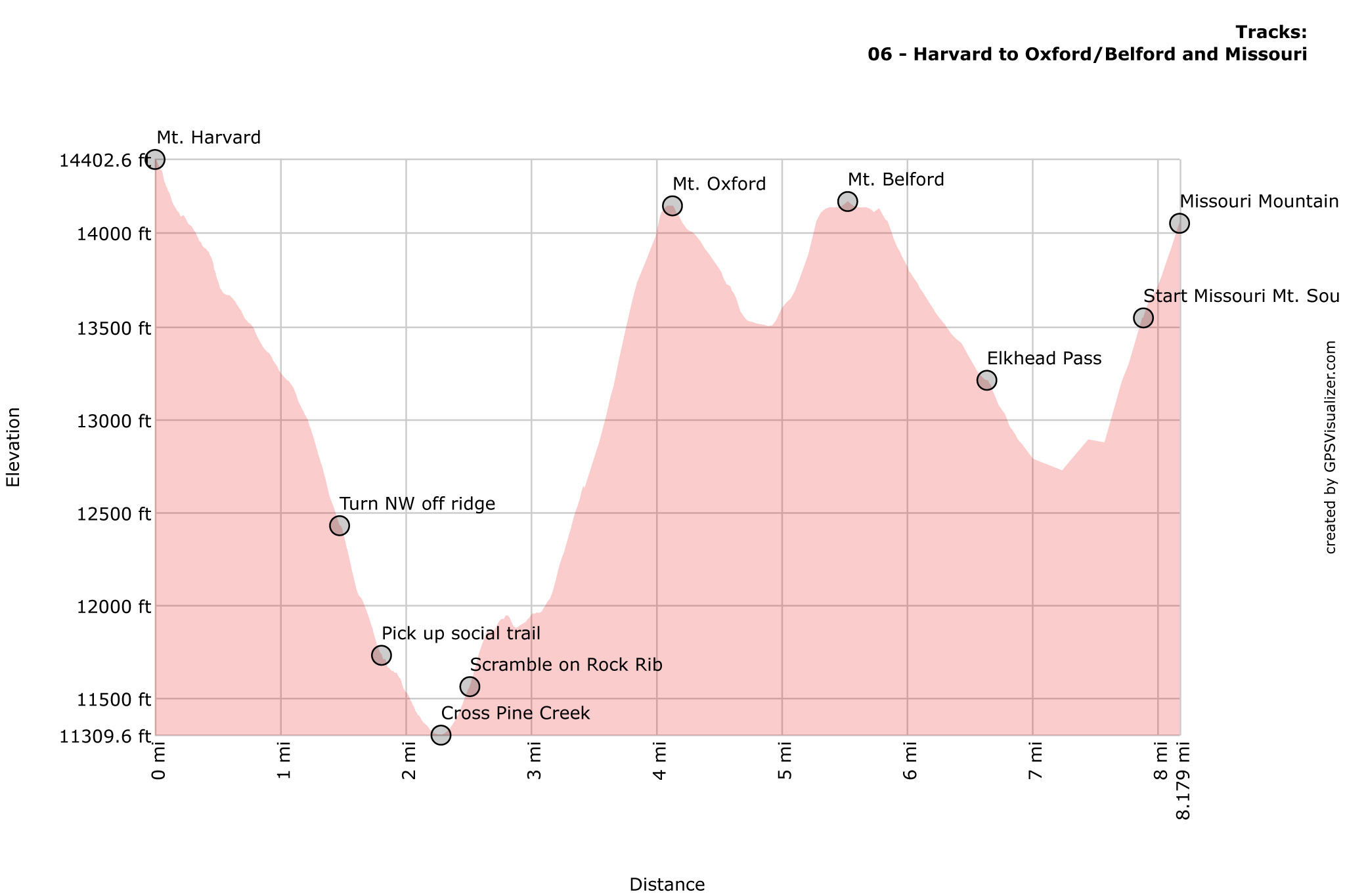
- 7.79 mi
- +4976′
- -5318′
Nolan’s 14 Line
0.0 Summit of Mt. Harvard. Descend directly off of Harvard’s Northwest Ridge.
.66 The Northwest Ridge broadens to a slope. Descent northwest down this slope at an opportune place.
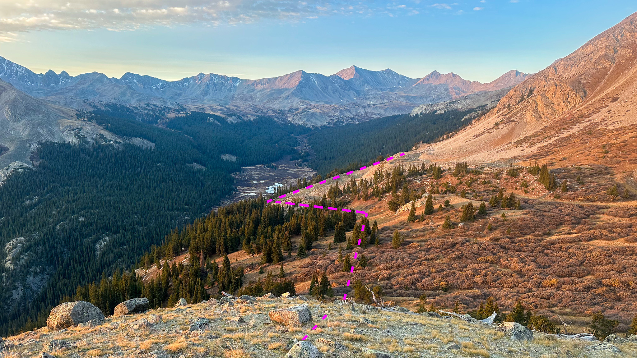
1.55 Near Treeline. The terrain below treeline can be very difficult with downed trees and cliffs. Try to pick up a social trail at approx 38.93824, -106.33875 that travels northwest through the forest. Finding this social trail could be the difference between an easy time to Pine Creek and a nightmare of navigating downed trees and cliffs.
1.94 Cross Pine Creek at a reasonable point at approx 38.94261, -106.34170 — you’ll most likely get wet, so decide if taking off your shoes is worth it.
2.03 Pine Creek Trail. Continue heading northwest and cross the Pine Creek Trail. Beyond the trail, find a talus slope that almost reaches the trail itself at approx. 38.94346, -106.34299 and start climbing up, staying at it’s rightmost side.
2.17 This talus field becomes choked with small trees. Move onto a convenient rock rib just to the right of the talus field at approx. 38.94498, -106.34351. Tree growth on the rock itself is sparse, giving you a convenient way out up.
2.31 You’ll get out of the trees for a bit and onto more talus at approx. 38.94685, -106.34329. Find a social trail to the south of the talus field heading northeast, which will guide you besides the talus field without having to do too much hopping.

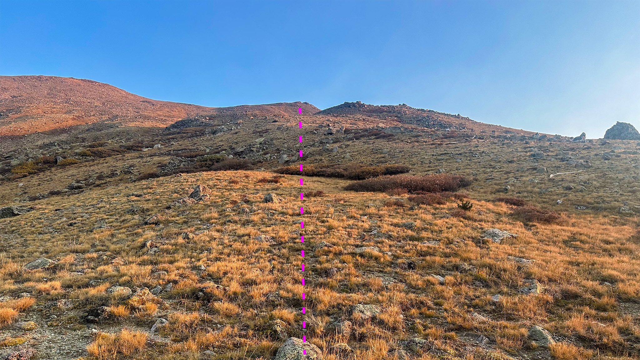
2.78 Reach a stand of old-growth trees at approx. 38.95204, -106.33964. Wrap around them, and find yourself finally free above treeline, with Mt. Oxford towering above you. Follow Mt. Oxford’s south ridge to the summit.

3.77 Summit of Mt. Oxford. Follow the well-beaten trail to Belford, crossing a trail that goes towards Elkhead Pass.
5.16 Summit of Mt. Belford. Fouble back again to the trail junction, and descend the other trail down to Elkhead Pass (38.95821,-106.35783).
6.27 Elkhead Pass. Keep descending south, then traverse west to the saddle of Iowa Peak and Missouri Mountain (38.94748,-106.36628). Resist the temptation to take Missouri’s Class 4 east ridge directly. It’s the most direct way, but the footing is incredibly loose, generally very slow-going, and difficult with a heavy pack.
7.5 Iowa Peak/Missouri Mountain saddle. Hike up Missouri’s South Ridge (Class 2) to its summit.
7.79 Summit of Missouri Mountain.
Slowlans Alternative
From the summit of Harvard, descend directly off of Harvard’s Northwest Ridge, until you reach Pine Creek. Careful with this creek crossing.
Continue north cross country until you meet up with Pine Creek Trail. Take this trail west until the trail junction with the Missouri Gulch Trail up Elkhead Pass Trail (38.93251,-106.34862). Take this trail north.
Summit Elkhead Pass. Take the trail towards the Oxford/Belford saddle east. Another trail junction will be found at this saddle – this is a good place to drop packs. Hike east to tag Mt. Oxford, which is only about a mile away. Double-back to the junction, and hike northwest to tag Mt. Belford.
Double back again to the saddle and descend once more to Elkhead Pass. Take the Missouri Gulch trail northwest, then west at a trail junction up Missouri Mountain’s standard route (38.95570,-106.37669).
Water
- Pine Creek makes a very dependable water source (38.94664,-106.33623)
- Water can most likely be source on the south side of Elkhead Pass, not far below the direct Nolan’s 14 line (38.93995,-106.36336).
- Water should also be available on the north side of Elkhead Pass in Missouri Gulch, although you may have to descend the trail to hit a reliable run of the creek (38.97153,-106.37327).
Camping
- Plenty of sheltered campsites can be found at Pine Creek (38.95476,-106.31434).
- High campsites can be found on the south side of Elkhead Pass (38.93953,-106.36650).
Bailing/Resupply
After Harvard
Take the Pine Creek Trail east to the highway. You’ll pass the Colorado Trail, and then enter into private property. The landowners ask for a small fee to enter their land from the highway side (around $1). It’s a very long hike out at around 9 miles.
After Oxford
Take the trail down to Elkhead Pass, then the trail south down Missouri Gulch, until you reach the trailhead at Chaffee County 390. Hitch out east to the highway.
After Belford
Take the standard route north down Mt. Belford and join the trail north down Missouri Gulch, until you reach the trailhead at Chaffee County 390. Hitch out east to the highway.
After Missouri
Take the standard route north down Mt. Missouri and join the trail north down Missouri Gulch, until you reach the trailhead at Chaffee County 390. Hitch out east to the highway.
Skipping
Skip Oxford by hiking up and Over Elkhead Pass from Pine Creek. Belford, and Missouri can be summited or skipped here as well.
If you want to skip Oxford, Belford, and Missouri, you can continue down the Missouri Gulch Trail to the Missouri Gulch Trailhead to Chaffee County 390, the hike the road west to the standard trail for Mount Huron. Just to the north of the Missouri Gulch Trailhead is the Sheep Gulch Trailhead, which goes up Hope Pass, and would allow you to skip Missouri and La Plata, rejoining the route on HW 82.
Another option to skip Missouri is to descend down south from Elkhead Pass, and traverse west to the Iowa/Emerald saddle, as you would when following the Nolan’s 14 line. You’re less than a thousand feet below Missouri’s summit here. Instead of summiting Missouri, continue west and pickup the Missouri Mountain Clohesy Lake Trail to Clohesy Lake.