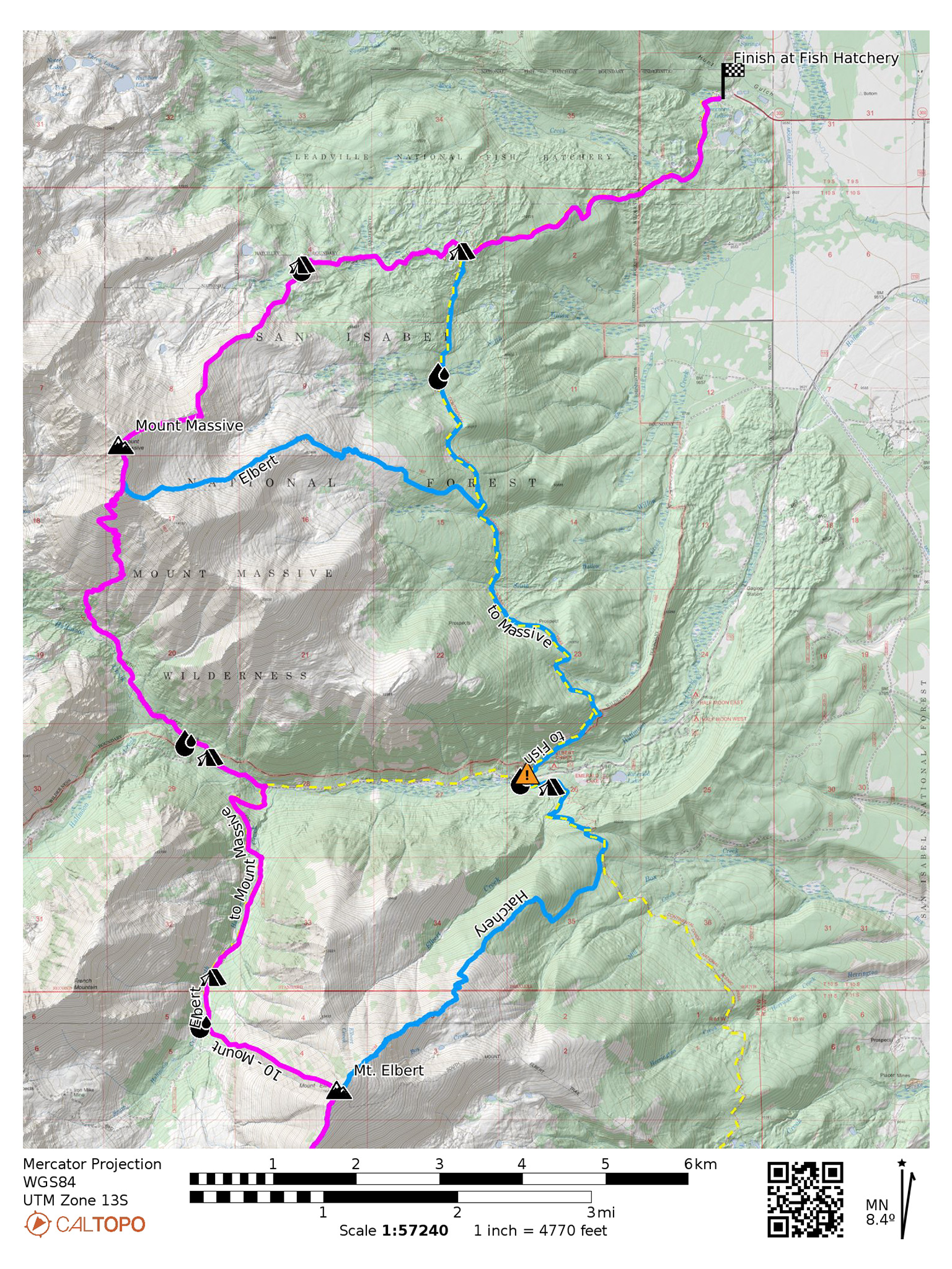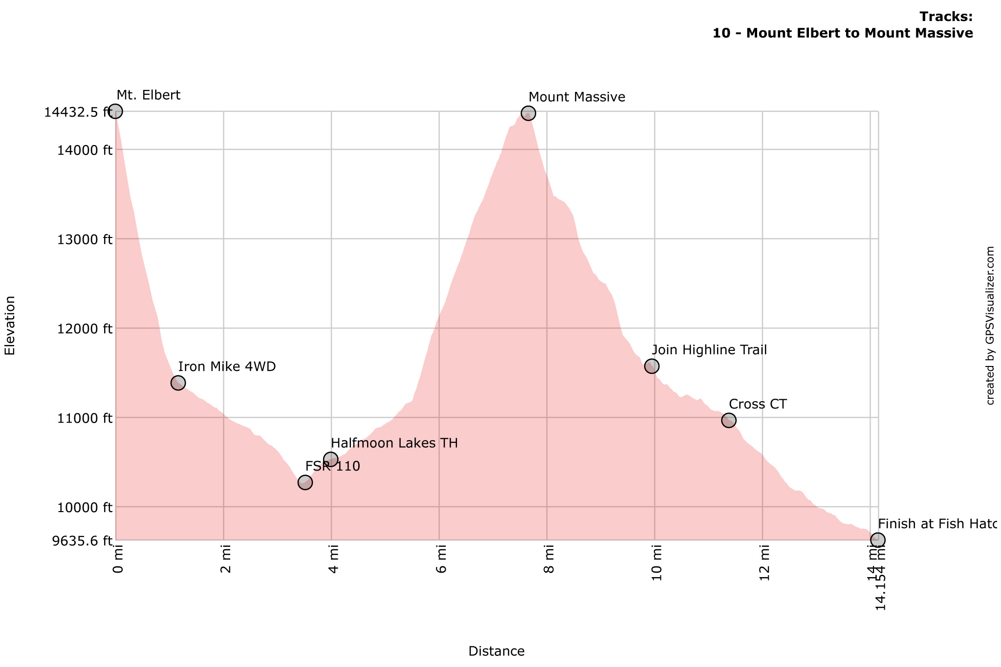

The final push! From the summit of Mt. Elbert, it’s a exhilarating dive into the South Halfmoon Creek Drainage, and down to the SW Slopes route for Mount Massive. A stout hike on a good trail to summit Massive, then a wonderful cross country romp down its northeast slopes and into the Box Creek Drainage until finally getting to the trailhead at the Leadville Fish Hatchery. Can you taste the coffee from City on a Hill, yet?
Nolan’s 14 Line Stats
- 14.16 miles
- +4225′
- -9017′
Nolan’s 14 Line
From the summit of Mt. Elbert, descend a steep ridge northwest towards FR 110.J/Iron Mike 4WD road. This ridge features some of the loosest rock of the entire route, so be especially carefully not to step on something less than solid. It’s also incredibly direct: from the summit of Elbert, you will descend over 3,000′ in 1.12 miles.
The final section down to the trees turns into a scree ski, where you may lose sight of your entire foot. Make your way through the small patch of trees towards the road. Follow 110.J/Iron Mike north towards FSR 110. Take FSR 110 west towards the North Halfmoon Creek trailhead. Take the Southwest Slopes (14ers route description) up Mount Massive and summit!
From the summit of Mountain Massive, take a shallow ridge northeast down towards your final destination: the Leadville Fish Hatchery. The ridge will kink north for a while, then go back northeast. Stay on the shallow ridge, down through treeline, aiming for a small twin lake you may be able to find through the trees (39.20660,-106.45037). The Highline Trail is found just to the north of the lake. Wrap around this lake, find the trail, and take it east.
The Highline Trail will cross over the Colorado Trail, continue east. The trail will then converge with the Rock Creek Trail and turn generally north. Continue on the trail, following the signs for the fish hatchery. Our track goes off trail for a small distance, to follow the canal itself to the trailhead. Soon, the trailhead itself will appear. Cross over its threshold, and and complete the line!
Slowlans Alternative
Elbert’s West Ridge is very direct, very loose, and not the most pleasant. Our Slowlans alternative takes the standard Northest Ridge (14ers.com route description) – one of the tamest Class 1 trails on any 14er. But, once you’ve committed to this alt. down Elbert, you might as well then take the also excellent East Slopes (14ers.com route description) up Mount Massive, rather than taking the Southwest Slopes.
On your descent, this trail from Mt. Elbert junctions into the Colorado Trail. Take the Colorado Trail north. Once almost at the trailhead for the Northwest Route, you’ll come to another trail junction that allows you to continue on the Colorado Trail, rather than going to the trailhead/parking lot specifically for Mt. Elbert. Take this left fork north to continue on the Colorado Trail.
The Colorado Trail will cross the FSR 110 road. Cross the road and continue on the Colorado Trail – the trailhead at the other side of the road also serves as the start of Massive’s East Slopes route. The trail to the East Slopes will break off from the Colorado Trail in a few miles. Take this trail junction west for the East Slopes Route. Summit Mount Massive.
To descend, reverse course down the East Slopes route to the Colorado Trail. Take the Colorado Trail north this time, until it crosses the Highline Trail. Turn right on the Highline Trail heading east. The trail will then converge with the Rock Creek Trail and turn generally north. Continue on the trail, following the signs for the fish hatchery. Our track goes off trail for a small distance, to follow the canal itself to the trailhead. Soon, the trailhead itself will appear. Cross over its threshold, and and complete the line!
Water
- 110J/Iron Mike parallels South Halfmoon Creek, which you will be descending after getting off the West Ridge of Mt. Elbert (39.12485,-106.46449)
- along Halfmoon Creek (39.15120,-106.41984)
- Near the La Plata Southwest Slopes TH (39.15529,-106.46666)
- Water is plentiful off the Highline Trail, started at the small Twin Lake (39.20660,-106.45037)
- Water can be found at small streams near the Leadville Fish Hatchery
Camping
- Along 110J/Iron Mike (39.12993,-106.46271)
- Along FSR 110, including at the Massive Southwest Slopes trailhead (39.15371,-106.46321)
- Off the Highline Trail (39.20660,-106.45037)
Bailing/Resupply
From the summit of Mt. Elbert, descend the standard Northeast Ridge trail down to the Mt. Elbert trailhead. Hitch from the North Halfmoon Creek Road to Leadville.
Skipping
Take the Slowlans Alternative down Mt. Elbert, and continue north towards Mount Massive. Don’t take the trail fork left up the East Slopes of Mount Massive, but rather continue north on the Colorado Trail to the Highline Trail.
Turn right on the Highline Trail heading east. The trail will converge with the Rock Creek Trail and turn generally north. Continue on the trail, following the signs for the fish hatchery. Our track goes off trail for a small distance, to follow the canal itself to the trailhead. Soon, the trailhead itself will appear.
Next: Leadville Fish Hatchery to Mount of the Holy Cross and Half Moon Trailhead